Thursday, May 29, 2014

Bayeux and Paris - the end

I'll make this the last post for our Normandy Trip.  We spent our last day, a Friday, in Bayeux visiting the famous Bayeux Tapestry and the Bayeux cathedral in the morning. After lunch we took in the Bayeux Battle of Normandy Museum. That evening we explored the walking path along the Aure river which runs through the city. The next day we traveled back to Paris for an overnight near the Charles de Gaulle airport and then our flight home on Sunday.

The Bayeux Tapestry is an embroidery depicting the events surrounding the battle of Hastings in 1066 where William the Conqueror invaded England (the Normandy invasion in reverse!), defeated the the English King Harold to become the King of England. The tapestry is pretty amazing in several aspects.  First, its sheer size - it's about a meter high and an incredible 70 meters long.  That's a lot of embroidery! It is composed of scenes depicting the events before, during and after the battle.  There are fifty some scenes, each with a lot of detail to depict the story.  Finally, the quality of the stitchery over this size is very impressive.  Apparently, it was done ten years or so after William's victory which makes it just short of a thousand years old.  It had been shown in its early years in the Bayeux cathedral but in recent times it is in it's own museum about a block away from the cathedral.  Here it has been preserved well and it is displayed in controlled conditions (no flash photography). It is well done and it really does have a lot of historical information in the various scenes.  This is really made apparent as you are guided from scene to scene with an audio phone from which an excellent description is given.  Without this you would have to do a lot of studying to figure out some of the detail.  The tour really gives a nice flow to the whole story.  In a separate room there is a theater with a good movie on the history and some of the detail on the tapestry. One of the scenes that was particularly interesting to me was one showing a comet at the time of the battle (later determined to be Hallely's comet).
Bayeux Tapestry scene depicting a comet (in the top running banner stripe, middle of the scene)

The Bayeux cathedral is another excellent example of the architecture of these grand structures.  The exterior is not as delicate or ornate as Paris or Rouen, but beautiful in its own right.  The interior is magnificent - grand columns, delicate arches and beautiful stained glass. It is a nice combination of Romanesque and Gothic styles. Interestingly, this site suffered no damage during WW II so it is truly in its original state.  Bayeux was well favored by the Dukes of Normandy and William the Conqueror presided over the consecration of its cathedral.  Bayeux is a small town and the cathedral spires are visible everywhere in the town - this makes it almost impossible to get lost there!  Another interesting bit of history at the cathedral is a portion of a preserved roman wall on the site.  So in one view you get to see structures 2000 and 1000 years old. Counting by millennia!
Bayeux Cathedral with Roman wall in foreground

The Battle of Normandy Museum was a nice recapping of the history of the invasion and subsequent struggle to break out of the Norman hedgerows.  By the way we did see many examples of these hedgerows and sunken roads.  They are formidable barriers and again, for the Germans, perfect defensive structures.  The Museum had films and good displays of vintage military equipment - personal items, small and large weapons, communications, clothing and more.  It really makes those times seem almost antique - there has been a lot of change in 70 years.

After dinner we decided to do a Bayeux finale with a stroll along the Aure river which runs through the center of town - actually right outside of our hotel.  Being spring, flowers were in full bloom and the river side (really a stream) setting made for a wonderful memory and cap to a great visit to Normandy.
Walking along the river Aure in Bayeux

However, we weren't quite finished.  Our return to Paris afforded us one last fling.  Our train got us in to Paris at early afternoon and we were in no hurry to go out to our hotel by the airport.  So we took a cab to the Latin Quarter and a nice Parisienne  bistro for one last delicious meal. A great ending of a great vacation!

Wednesday, May 28, 2014

Normandy Invasion Beaches - continued

I ended the last post with a few photos of the American Cemetery above Omaha beach.  Our first visit at the cemetery was part of an all day D-Day history tour so we didn't have a long stay.  We planned to revisit on our own in a day or two depending on the weather (see below), but for now I'll give our first impressions.  It's quite big, officially 172 acres, beautifully landscaped and manicured. On this day it was getting special attention as the official ceremonies will be in about a week with many dignitaries, including President Obama.  Unfortunately this translated into some of the sections being roped off, but others were open and we just strolled into those.  It is very reminiscent of Arlington. The white crosses and Stars of David are aligned in military precision and their mute message was loud and clear - sacrifice.  It is just stunning to see this, especially coming up from the beach where many of these soldiers gave their all (note - the cemetery contains about 9,400 graves but these are for all the Normandy battles, not just the invasion phase). The location of the cemetery overlooking Omaha reinforces the connection between the two. As you walk among the markers you can easily glance down to Omaha beach and the channel beyond. There are several buildings or monuments as part of the complex and they too focus on the bravery and sacrifice embodied here.  We wanted to just stroll around and try to let it all sink in.  The markers had the names, ranks, date of death and home state while at the bottom on the reverse side was their service number - simple and powerful.  We had brought a few packets of small American flags that we planned to place at markers that called out to us.  We looked for those from our home states, but one that really caught my attention was inscribed only as:

Here Rests in Honored Glory
A Comrade in Arms
Known but to God

For me this symbolized all that was here.

So the tour continued from the cemetery to Point du Hoc where US Army Rangers scaled shear cliffs to silence guns that threatened both Omaha and Utah. This was one site where the grounds were left as they were at the end of the battle.  Before the Rangers attacked, the site was heavily bombed and the grounds are still like a moonscape of craters.  Some were as deep as 10 or 20 feet - hard to imagine being anywhere near this and surviving.  Huge chunks of concrete were strewn about, but apparently the Germans were holed up deep underground in bunkers with immense thicknesses of reinforced concrete.  So the Rangers were called on to finish the job. It is just an incredible story that about 200 men were able to scale the cliffs under fire, capture the site and hold out there for several days.  Less than half survived.  Looking down to the waves below the cliffs was a stunning view - impossible to imagine how they did this.

Next stop Saint Mere Eglise. This town was a key objective for the US paratroops dropped here in D-Day's early morning, moonlit darkness.  It is mainly known by the story of a paratrooper whose parachute got caught on the town church bell tower causing him to be trapped hanging on the side of the church.  The church today is much like it was in those days - a typical stone church with bell tower.  The town however is larger and modernized a bit - tourist parking lots and museums.  The church features a replica of the paratrooper still hanging from the bell tower by his parachute.

Church at St. Mere Eglise

Utah beach seemed to have less fanfare than Omaha - fewer memorials and no dramatic bluffs overlooking the beach. The beach has a good sized sand dune that provided cover and the belts of obstacles here were apparently fewer. Nevertheless, it still recalls the brave men who rushed ashore those many years ago.  The fighting on the beach was less intense here, but lives were still lost and the battle really developed inland. The inland landscape was dominated then by flooded lowlands which are today lush low-lying pastures.  The paratroopers did their job well and Utah beach was largely sealed off. The infantry and paratroops quickly joined up and shifted the battle to deepening the beachhead.
Utah Beach

The tour then took us to several inland sites where significant events occurred.  Two of these were stories of small groups of soldiers doing amazing things.  The first of these was the capture and defense of a small bridge over the river Merderet inland of Utah beach.  At this place a few brave paratroops held off a significant German attack, which included tanks.  It was amazing to view it today as a gentle pastoral landscape, a small bridge and gentle flowing stream.  This was the basis of the final battle scene in "Saving Private Ryan" except it was in reality well out in the countryside, not in a small town as depicted in the movie.  There were some farm buildings around, but no town or village.  Still, apparently the battle raged fiercely as depicted in the movie.

The last stop on the tour was even more moving.  It was at a small village named Angoville - Au - Plain, again inland of Utah Beach. Here, two paratroop medics, really just youngsters, collected wounded - both American and German - into the village church so they could be treated and sheltered.  They kept at it while the battle raged about them and while the village ownership changed hands several times.  The Germans respected this and were grateful to bring in their wounded when they controlled the village.  Today, the church has several stained glass windows celebrating the paratroopers, and displays several pews still with bloodstains.  Outside, several monuments recognize these two brave men.
Church at Angoville-Au-Plain

The next day - this would be Thursday - Cath and I wanted to revisit some of the invasion sites on our own so we could spend more time and to explore on our own.  Primarily this was the American Cemetery at Omaha, but there were a few other places.  The weather turned our to be very cooperative - blue skies with a few clouds.  So at the cemetery we again strolled the grounds, but at a more leisurely pace. One grave site I wanted to visit was that of General Teddy Roosevelt, Jr who was the assistant division commander at Utah and died a few days after the invasion.  He received the Congressional Medal of Honor for personally leading the 1st landing waves at Utah and personally directing the initial battle.  Several things were significant about his burial site.  First, Congressional Medal of Honor recipients have the lettering of their names, rank, etc. in gold and with a gold star above their names.  The other thing of significance is that his brother, Quentin Roosevelt, who was killed in WW I was re-interred to a grave next to his brother.  A very touching thing to see.
Graves of Quentin (left) and Teddy Roosevelt, Jr (right)

One of the most inspiring things to see was the large numbers of school children at both the cemetery and on the beach.  At the cemetery they were being led on tours and also taking part in ceremonies.  Hopefully the lessons of the past will not be forgotten.

We also wanted to back down onto Omaha beach and I wanted to do in in a particular way.  That was to follow the path that was taken by one of the first soldiers who managed to get off the beach and up to the top of the bluff.  This was a Captain Joe Dawson and his story is very famous in this battle.  So there is now actually a small paved path of his route from the beach to the cemetery and this is the route we took.  I have read his oral history and this path is amazingly accurate to his description,  This really added to the personal stories aspect of our visits. Afterward we followed his story a bit further by going to a small village, Colleville-sur-mer, about a kilometer from the cemetery where Captain Dawson let his troops to capture a part of this village by the close of the invasion day.  Quite an interesting story and it was very touching to literally follow the footsteps of this story. Dawson never claimed any personal honor in his actions and he attributed everything to his "magnificent" soldiers.  He was nevertheless awarded the Distinguished Service Cross that was presented to him personally by Eisenhower. (If anyone is interested, I have a copy of Dawson's oral history of his actions on D-Day, plus a letter that he had written to his parents afterward.  Both are amazing to read)
Church at Colleville -sur-mer

Church at Colleville-sur=mer shortly after D-Day
Finally, I had one more spot I really wanted to visit. This was a little town back near Utah Beach where my father had been just after he entered France at Cherbourg. This was in September of '44, well after the invasion. His unit was first to land at Cherbourg direct from the US.  They had to delay in Normandy (Army = hurry up and wait!) until their supplies caught up with them.  So there was no fighting there, just further training.  Anyway, I wanted to visit the area.  The town is called St. Germain de Tournebut and it is a tiny crossroads village of 300 people, stone houses and a stone village church.  It's mostly surrounded by apple orchards and the mass of soldiers were camped out in those orchards.  So I just wanted the pleasure of touching base with this event.  So we drove up there, found the village and walked about the church.  We couldn't find a cafe, but at least we did visit the area and enjoyed the Norman countryside.


Church at St. Germain de Tournebut

So that was our free day in the invasion area.  The next post (and last) is our last day in Bayeux (the Bayeux Tapestry and the cathedral), plus our return to Paris for travel home.


Monday, May 26, 2014

Bayeux and the Invasion Beaches

I'm writing this as we wing our way home on Sunday the 25th, but it's all really well in my memory so it won't be hard to relate things here. We spent 4 days in Bayeux so I might break this into two separate posts. I don't know if you have figured out that I'm doing these from my smart phone without a blue tooth keyboard - and it's one finger pecking unlike what teenagers seem able to do. So I think for both you and I two parts will be better!
Our plan for the Bayeux stay was for day 1 to be a mid day arrival from MSM and to do a guided, 2 hour walking tour of the city. Day 2 was planned as a professionally guided, all day,  small group tour of the American invasion beaches as well as some of the key American paratroop sites.  This day was locked in schedule-wise. Days 3 & 4 were weather dependent and to include one day for tours of the Bayeux tapestry and the Bayeux cathedral, then one day for a revisit to the American military cemetery, Omaha beach and a small village of special interest to me (more on that later). The Bayeux days were tue-wed-thurs -fri of this last week. So that is pretty much what we did and the weather was amazingly cooperative.
I have to say that I was pretty worried about the weather. We had been VERY lucky so far with mostly sun or part sun and just a sprinkle that was hardly worth an umbrella. Unfortunately the forecast for Bayeux looked like full rain. As it turned out the forecasting in Normandy - off the channel - is notoriously difficult. History should have keyed me to this as Eisenhower had a similar problem! So to save the suspense there was only an occasional sprinkle, one brief downpour while we were in a museum, and sun or partly sun the rest! Amazing luck.
So after an enjoyable drive up from MSM we arrived about lunch time Tuesday and a quick bite before the 2PM walking tour start. Just a quick note on the drive. I deviated from the GPS route so we could go by St. Lo which was the site of the American battle to break out of Normandy. This "detour" also enabled some good back road views of the Norman countryside. All of these places such as St. Lo have some very interesting stories attached to them, but I can't really do all of them here. I'd be happy to give any of you some of these if you'd be interested.
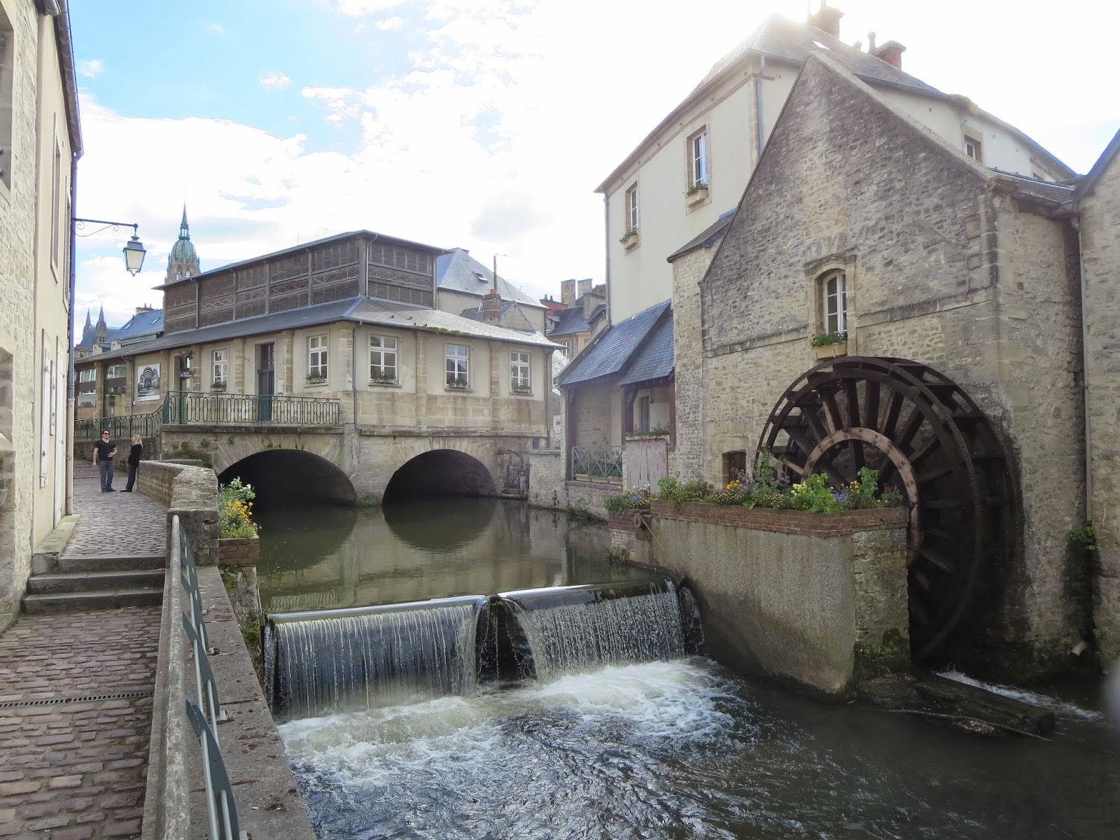
Our hotel in Bayeux was the Rhein Mathilde which means Queen Mathilde who was the wife of William the Conqueror. Both of these two played an important part of Bayeux's history. The hotel turned out to be a really good choice as it was very nice, a great location and had a good restaurant.
The walking tour was something I had discovered browsing the web. It is called Discovery Tours. You just show up at the appointed place/time, pay the fee and do the tour with a local guide. As it turned out Cath and I were the only ones there so we had a personal tour! Our guide was a lovely young lady and she gave a wonderful tour with lots of history and interesting sights. We would never have discovered half as much on our own. A really fun time. She was actually quizzing us as we went along to be sure we were absorbing her info. Great fun. After the tour we had evening to ourselves with lots of interesting choices of restaurants. Meals did not disappoint. There were always interesting and delicious Norman specialties on the menus and desserts were out of this world. Sorry if I'm a bit over the top here, but...
Day 2, Wednesday, was the D-Day history tour. There were several available and I chose "Overlord" tours based on recommendations - especially that of Rick Steves. By the way his guide books, hotel and restaurant recommendations were really near perfect as far as we are concerned. So the tour was a group of 8 (4 couples) in a van. The guide was a Brit (50ish) who had a personal interest and a really excellent knowledge of the invasion story. He actually lives inland a bit from Utah beach. He had many stories of events that were down to the individual or small group level which really gave a personal feel to this otherwise big story. He often took us to locations off the tour agenda to where these individual events took place - a small bridge, a stream crossing or a village church.. It really made the history of this day come alive.
I probably can't relate everything from this tour so I'll do my best with some of the highlights. I'll be happy to tell you more over cups of coffee. 
First the weather. It was a somewhat overcast day, but no rain. In actuality this fit pretty well the way it was on June 6, 70 years ago. This actually gave an definite mood of realism to our visit.
Omaha beach is breathtaking. If it didn't have such a horrific story it would be described as a perfect sea-side setting. It's a 3 mile long crescent beach, tan sands, a flat wide beach at low tide (reminiscent of south NJ beaches such as Wildwood and Cape May). On clear and even mildly hazy days you can see the whole 3 mile length of the beach. Along this whole length the beach rises on a scrub/shrub covered slope to a height of about 100 - 120 feet to the flat Norman country side. Also along this length there are 5 exits off the beach. At the time of the invasion I believe only 2 or 3 of these were paved or vehicle worthy. The others had only walkable paths. These beach exits are like valleys or wide gullies cut into the slope. At either end of the beach, the sloped bluff changes to abrupt cliffs with no natural exits. As to the flatness aspect of the beach it is quite amazing at low tide. It goes out as far as several HUNDRED yards. Easily 200 and possibly 300 when we were there (low tide). This was open beach, threaded with rivulets (often called runnels) and small pools. 
Given this geography the beach landing was confined to the 3 mile section between the cliffs. So that is what you see today.  Why land here at all? Without Omaha there would be a big gap between Utah (which was critical for the capture of the port of Cherbourg) and the Canadian beach (codenamed Gold).  A gap between these beaches would have allowed the Germans to keep a separation between these forces - divide and conquer.
So back to the Omaha landing. The description I outlined above could have been for a vacation brochure, but of course when you think in terms of the invasion these features all had very different implications. Low tide was selected for the 1st waves so that the forest of beach obstacles (obstacles for the landing craft, not the troops on foot) could be blown or avoided. But this meant the troops had to run or crawl those long several hundred yards into murderous fire. The bluff along the whole beach gave the German defenders an absolutely perfect defensive situation - firing downward on the troops from above and left/right along the nicely curving beach. The exits also had significant implications. The Americans had to capture them to move equipment off the beach. But the Germans realized this too and so focused their defenses there.
So when you stand there all of this comes perfectly together. At the same time so do the contrasts of then and now - now a beautiful seaside beach, then a killing field, an impossible thing, and yet a costly success.
Let me add a few additional comments. How did it come to be a success. It almost didn't. Most of what was planned turned out to have failed. Most of the floating tanks didn't make it in to the beach - something like 3 out of 50 made it - appalling losses. The leading wave demolition engineers were only able to clear a few paths in the obstacle belts. This led to losses of many troop filled landing craft. The preliminary air bombardment completely missed the beach (remember the low overcast). The plan to focus on the beach exits via direct (frontal) assault failed due to the incredibly strong German defenses. Finally, the near total confusion from landings at wrong spots, significant losses of men and material, loss of leaders and the unexpected hail of murderous gunfire greatly affected the ability of the troops to do anything but seek survival.
The things that did work were as follows: a few incredibly brave, often leaderless, soldiers - privates, sergeants and officers -  decided to scale the bluff between the exits and then attack them from behind - this worked. It wasn't in the plan,but on the ground it was the right thing to do. Also the relentless wave after wave of additional troops being landed basically overwhelmed the defences - the Germans were literally running out of ammo. And finally, the brave skippers and men of 5 navy destroyers who came to within 900 yards of the beach, some scraping the bottom,  to pour, point blank, 5 inch navel gunfire at the defenses on the bluff. It took well into the afternoon for significant penetrations up the bluff and cost something like 2000 KIA and many more casualties - indeed "the longest day".
Well, it was actually much more than all of this, but this is the short version. There are many individual stories - tragedies and heroism. It really must be seen to really appreciate what happened there.
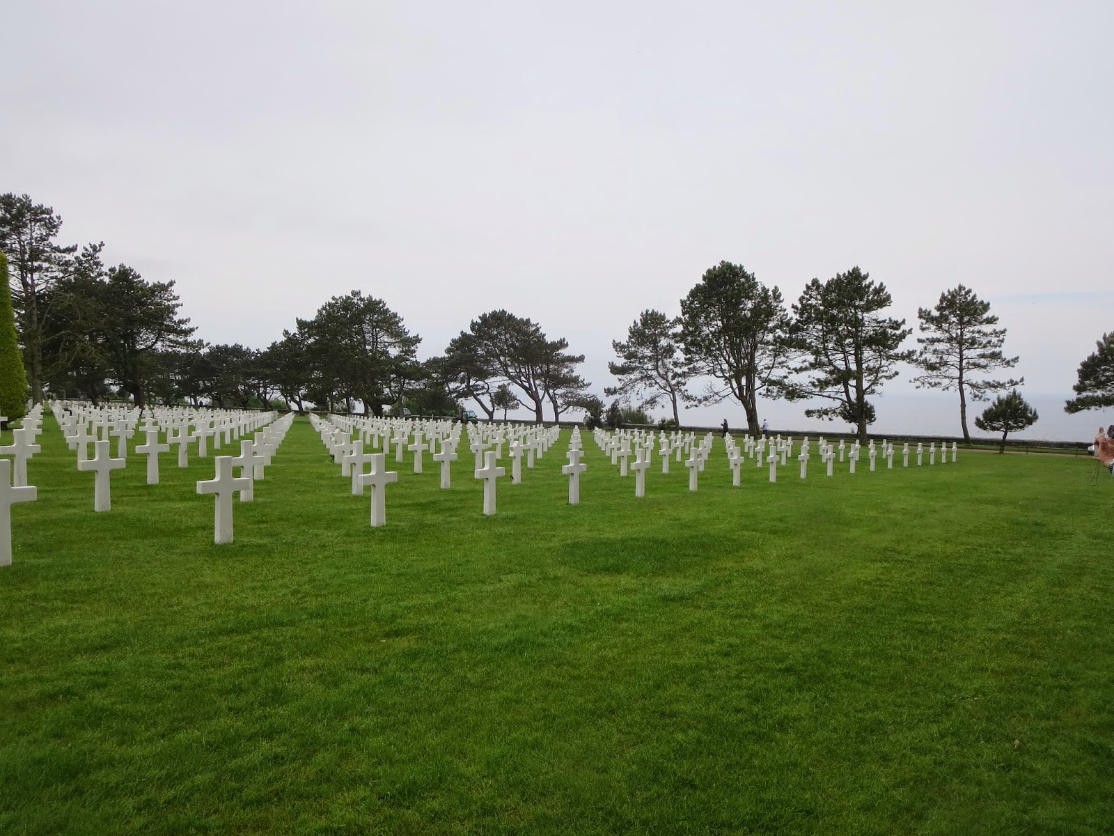
And then there is the american cemetery, just above the bluff about in the middle of the beach. I think I'll pick this up in the next posting along with Utah beach and the paratroop areas.

This first photo is taken from about half way out on Omaha beach looking back onto the bluff with the American cemetery just at the top of this bluff area.
 This photo is the same scene, but taken closer in to the bluff. The American cemetery is just past the trees lining the top of the bluff.
 This photo looks out onto the beach at low tide (all of these are at low tide). At the middle right side are people further out on the beach giving a sense of the distance at low tide.
 A view along the beach near where the bluff begins.  This scrub covered sand dune is where a rock pile used to be located that gave some cover to the troops that made it this far.
 This photo is a view of the beach from the top of the bluff at the American cemetery. This is a view that the German gunners would have had, although they were dispersed all throughout the slope of the bluff. There is now a walking path from the cemetery to the beach. Cath and I took this trail when we revisited here the next day.
 This is a view of a portion of the American cemetery that shows the distant channel beyond the line of trees.

Friday, May 23, 2014

Le Mont Saint Michele

On the road to Mont St. Michel. It's about 120 miles to MSM from Honfluer, but driving in France is an unexpected pleasure. Of course GPS takes away the stress of navigation, but the roads are excellent and signage is too. I'm also pretty happy with myself doing stick shifting after a many year lapse. I guess it's one of those things you never really forget.

We chose a fairly direct route since we wanted to maximize our time on MSM, so the roads were a mix of two and four lane. Views of the countryside were excellent and Cath was taking plenty of photos. This area is what I would describe as inland Normandy - it's been well away from the coast with a mix of forest and farmland. It is also where the final battles of Normandy took place. About midway on our route is where Patton's 3rd army nearly surrounded the German 7th army. Further south on the route near Avranches is where Hitler ordered a futile attempt to pinch off the American break-out. The Americans prevailed and Normandy was finally liberated.

So as our route looped us around Avranches Cath saw MSM appearing above the horizon - a really neat view. As we drew closer the roads became very rural with farms and small villages. At many spots we could see the Abbey poking above the fields and stopped for photos.

We arrived about noon and got to our hotel. There are vehicles allowed on the mont so you park in a large lot on the mainland and take a shuttle to the foot of the mont on a causeway. From there you walk to the entrance gates. It was low tide and the Mont was surrounded by mudflats and a few channels of water. Otherwise the coast line was pretty far out.  We decided on a quick lunch and then a climb up to the Abbey at the top of the Mont. The village at the base is very small. One narrow cobbled street about a quarter mile long, but curving around and sloping uphill. Lots of souvenir and gift shops along with a few small hotels and restaurants. Then the climb into the Abbey proper begins with stairs and ramps - all stone. There are many stops along the way with views of either the Abbey above or the coast and distant channel. It is a long way up, but not too difficult.

The Abbey is really a small cathedral. Very beautiful inside and out. Massive columns, stained glass, quiet gardens. How did they ever lug all those stones up there and work them into an intricate design??? Amazing and worthwhile site.

Back in the village dinner in a nice restaurant with a beautiful view across the estuary to the distant mainland. After dinner we went out to some of the ramparts where we could see the Abbey in the twilight and as its nighttime illumination came on. We were also able to see the tide begin to rush in and fill the estuary at an  an amazing rate.

So this has been a day filled with loads of amazing sights and experiences. By the way  the weather has been pretty nice all the way from Paris to here. A mix of sun and clouds, temps cool to warm. Today a few threatening clouds, but still pretty good. So will our luck last?? Stay tuned!

Tomorrow on to Bayeux and the sites of the WWII Normandy invasion.

Photos: MSM rising on the horizon; MSM as we approach on the causeway; MSM with nighttime illumination

Wednesday, May 21, 2014

Jumieges and Honfluer

After leaving Rouen, the Abbey of Jumieges was our first stop. It's an easy and beautiful drive through the French countryside. The river Seine takes great loops through this area and Jumieges is is tucked in one of these loops. What a beautiful sight - brilliant white stonework in a quiet park setting. The local village is just a handful of buildings across from the Abbey site. The Abby is actually in partial ruins and it is not anymore active, but it is still breathtaking.  The main towers still stand as well as some of the side walls so it is easy to imagine what it would have looked like.

This site was first established as an Abby in the 600s, burnt by the Vikings in the 900s and the large structure was begun later that  century by William Longspear, Duke of Normandy (a descendant of Vikings!). The Abby was finally consecrated in 1067 by another William (the Conquerer) who apparently had a busy schedule those last few years! Sadly it again saw decline during the 100 years' war and the French revolution. Throughout all of this and even today it remained a pilgrimage site on the so called Abbey trail. Amazing history.

Today it is still amazingly beautiful, even in partial ruin. The brilliant white stonework and the quiet park-like setting just draw you in. Maybe also it was the warm air and sunshine!

So after our walk-about we went across the street to a cafe for coffee to be enjoyed on the flower decked patio - perhaps like many earlier pilgrims.

Next, on to Honfluer. 

Honfluer is a beautiful small port at the mouth of the Seine. The main port, le Have, lies on the north side of the river so Honfluer is mainly for small fishing craft and yachtsmen. Like many places here, its history goes back to viking times and even earlier, but its name is of viking/Norse origin. In more recent times it is known for impressionist art. But nowadays I think it is mostly a great get-away for relaxation, sights  and eating and enjoyment. Day trippers and weekenders from both Paris and England are known to come here. So it seemed a logical place for us to start our channel coast explorations.

From Jumieges it was an easy drive of less than an hour. We took a route on the north side of the river that would take us over the pont de Normandy - a very modern, very high and long cable stay style bridge. A real thrill for bridge enthusiasts.

Our hotel, the l'Ecrin was VERY nice! It was like a small chateau. Lavish decorations and a wonderful garden.  The town center was an easy quarter mile stroll through cobbled streets. The center is built around a small, square harbor. The buildings surrounding the harbor are almost entirely restaurants - all with outdoor seating. So you stroll around the harbor until you find a menu to your taste and enjoy a meal with a harbor view and lots of people watching. After a meal there are shops along all the side streets. There is also an interesting wooden church in town. Wood working craftsmen from the boatbuilding trade apparently dominated the stone masons!

Overall, Honfluer was a great spot and we highly recommend it.

Next, off to le Mont St. Michel.

Photos: Jumieges Abbey, Honfluer harbor.

Monday, May 19, 2014

Rouen

Our next stop is Rouen, the capitol city of Normandy. We wanted to see the old town with its cathedral as well as some of the sites with Joan of Arc history.

Rouen is an easy train ride from Paris - a little more than an hour trip. We picked up our rental car at the Rouen train station and got to our hotel after a few glitches finding parking. Thank goodness for GPS - many thanks to our friend Victor who lent us the France map chip! Our hotel at Rouen was the le Cardinal - a small family run hotel just at the cathedral's plaza. A great view of the cathedral from our room, especially at night with the exterior illumination. Very nice hotel - clean, friendly and great location. Lunch on the cathedral plaza - a Normandy salad, wine and coffee. It just occurred to me that except for breakfasts, we have eaten all our meals outdoors! I think we are becoming addicted to this life style!

As you, my readers may have come to suspect we are very interested in the history, architecture and art of Christian places of worship in old Europe - from small, one room chapels to grand cathedrals.  I even have Cath talking Roman vs. Gothic arches! The Rouen cathedral did not disappoint. Each cathedral seems to have a unique character, but they all are amazing especially considering when they were built. I love the architectural elements - Gothic arches, buttresses, vaulted ceilings and of course the stained glass. This cathedral suffered serious damage in WW II, but has been repaired except for some of the stained glass. The exterior stonework - how do they turn stone into lace (?) -  clearly draws you in, but inside you are humbled and made to feel small! This is a good example of this style, but not the most spectacular that we have seen before (Cologne, Strasbourg). Still it was a worthwhile sight.

I should tell you that one of the reasons I wanted to come to this cathedral was from a schoolboy fascination with Richard the Lionheart. So here in the cathedral was his tomb which I really wanted to see. Nothing grand, just a fine sculpture, in repose, nearby the alter. Still it was stirring to actually connect with my early daydreams of grand knights! Richard was one of the fabled dukes of Normandy in the line of William the Conquerer. Wow, history!

OK, next we walked the old city - narrow, cobbled streets crammed with shops.  There were many sections full of half timbered architecture. By mid- afternoon the streets were jam packed. The Joan of Arc memorial church is at the end of the pedestrian section of the old town. It is marked by a tall metal cross at the spot where she was burned at the stake. A statue of her looks lovingly at the cross.  Very sobering. The memorial church is modern both inside and out - quite a contrast to everything else in the old town.  It is very nice - especially the stained glass which fills one complete wall.

So that's a snapshot of Rouen. Next stop will be the Abbey of Jumieges and the port of Honfluer.

Photos: Rouen cathedral, cathedral interior, night illumination, Joan of Arc cross

Saturday, May 17, 2014

Day 2 in Paris

Day two, dawns sunny and a promise to be warm. Perfect weather.  A full agenda planned for this day - Eiffel Tower, hop-on/hop-off Paris city tour and an evening dinner cruise on the Seine river.

So to beat a long line for the tower we planned to get there about a half hour before opening. So this necessitated an early breakfast and taxi through Paris morning traffic. All worked well and the line was not long. The tower was spectacular and we went to the top. Fantastic views of Paris and the Seine river. Afterward we walked the Champs de Mars for some ground level views of the tower. I think it is the most graceful from a distance. Truly a modern marvel.

We picked up the city tour bus near the tower. A double decker with open air on top for good viewing. This really gave a nice overall perspective of the city. Great views of the Invalides and Louvre museums, Arc de Triumph, Champs de Elyse, the high end shopping district, Notre Dame, Pont Neuf, and the bridge with thousands of "marriage" locks.  We got off at the Louvre for a fun walk around the central courtyard with its glass pyramid. We also got off near Notre Dame for lunch at an outdoor cafe. Great food, sunshine and people watching!

Our last hop-off was near the marine museum across the Seine from the Eiffel tower. There are great views of the tower here, plus a beautiful plaza, fountain and park. The dinner cruise start point was just a short stroll across the bridge to the tower side. So overall the bus tour was a real success.

I hate to say it but the dinner cruise turned out to be a disappointment. The views were good, but the problem was it was like a greenhouse inside the glass enclosed boat!  Even though it was evening (6:30 - 8) it turns out that here in Paris in mid May sunset is about 9:30 and it is still light out at 10:30! So the boat was in quite bright sunshine for the whole cruise. This added another problem - the city lights on bridges, towers, etc. don't come on till 10ish so we really didn't get much of a view of Paris's famed night lights. But I shouldn't complain - it was still worth while.

So, for the last night in Paris we took a leisurely stroll along the Latin Quarter's Boulevard St. Germain and back to our hotel. A very good day.

Tomorrow sees us off to Rouan.

Photos: Eiffel Tower; Bob & Cath at Louvra; a Hearty chicken provençal lunch with French onion soup